Saturday, November 28, 2015

South Mountain Loop Turkey Burn

Patches on top with Hood Canal, Cascades and North Mountain behind her.
Note the brown smog line over the I-5 corridor


Turkey burn 2015.  I like to burn the turkey on South Mountain, so that is what I did.  I started my hike at 9am and it was a little bit chilly.  My progress up the hill was really slow even though I was feeling good.  I was stopping to take a lot of pictures.

I was on the top by noon.  I hung out and took some pictures in the wind.  I don’t like to spend too much time so close 
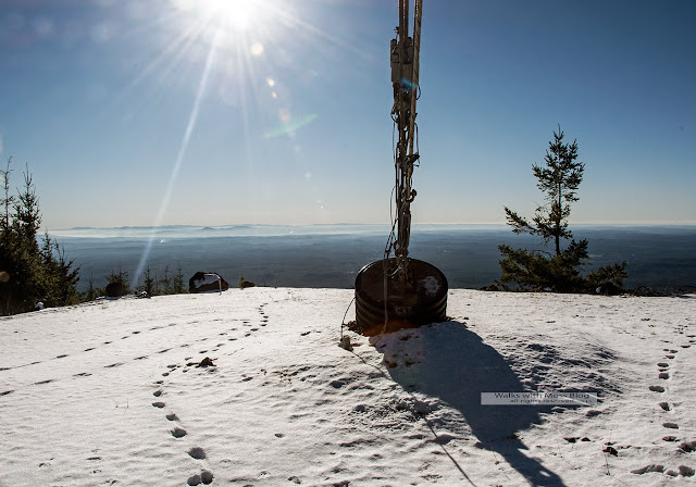
to the tower, so I only stayed for about half an hour.   The view was very clear but I still could not see Mount Hood.  I’ve read that Mount Hood can be seen from up there, but I’ve never seen in.  All three big volcanoes were out though.  There was a dusting of snow on the top, maybe two inches.


The plan was to traverse the summit and then come back down the way I went up. I traversed to the other two radio tower locations on the mountain.  Then I decided that I would rather do a loop hike that was 2 miles longer then have to trudge back up any hills.  I would hike up South Mountain and down North Mountain and then hike on the road that connects to two.

At about 3 pm I realized that I was running out of light.  I checked my GPS and discovered that I was 5 miles from my car with just one hour to go until sunset.  Uh oh, this was going to be an unplanned night hike.  I knew that my head lamp had good batteries, so I was set.  I never do a day hike without my headlamp packed.  I never know when I will get caught in the dark on a long day hike.  If I was really worried about night hiking, I would pay more attention and not get caught out so easily.  This is the second time this year that I did an unplanned night hike.  The moon was full and that made me feel better.

Just after sunset but before dark I stopped for a cuppa.   If I know that I am going to get caught by the sunset and have to hike in the dark, I have a strategy I follow.  Shortly before dark, I stop and brew a cuppa and get out my headlamp. I could use that last bit of light for hiking, but instead I use it to get ready for the dark. Once full darkness hits I know I won't want to stop and sip tea, I'll be too nervous to do anything but keep moving. I like to know where my headlamp is before it gets too dark to find it too.  After my cuppa I hike without my headlamp as long as I can so I can keep my night vision.

So I stopped and had a cup of coffee and a turkey sandwich.  Patches ate the last of a pound of hotdogs that I packed for her.  Then, headlamp and coffee in hand we started our hike in the dark.  The thought that cougars are most active and dawn and dusk played on me.

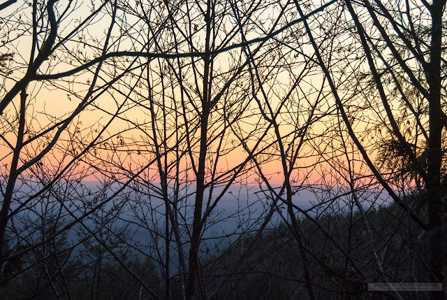
The moon did not come up at all and the woods were quite dark.  The sunset was pretty, but also scary because I was so far from my car.


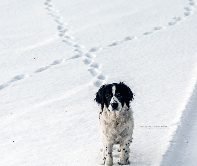
I was glad to have Patches for protection.  I heard a scary sound in the woods and I screamed.  It was just Patches.  Patches kept running off into the woods and making scary noises.  Thanks Patches.   I wish she would hike closer to me when it’s dark.

The only time I was really scared was the entire time I was on the main road.  To do a loop back to my car I had to hike on an open road for a couple of miles.  I did not want any yahoos to see me out there, a female alone at night.  I planned to hide in the woods if any cars came.  I stopped fairly often to listen for cars.  That was a good plan until I got to the part of the road with a  swamp on either side.  I walked quickly to get through the swamp.

Once I was a tenth of a mile from my car I relaxed and tried to photograph the Milky Way, but I was far too tired to get a good photo.  No cars passed me out there, so I was safe the entire time.
I made it back to my car at 6:10PM  I had hiked in the dark for a full hour as the sun had set at 4:30 and darkness sets in one half hour after sunset.


12 miles with 2,200 feet elevation gain, that’s a lot of turkey.

I made a video and I will upload it when I have a decent connection


Bald Eagle? These were huge


Rabbit tracks made me think of my mother and cry

Skokomish River Valley


Note the brown smog line over the I-5 corridor


Coffee at dusk


My 2016 Olympic Mountain Calendar is for sale now


My 2016 Olympic Mountain Calendar is for sale now!  Please support me and my blogging efforts and grab yourself a calendar:

Beautiful images captured while hiking hundreds of miles in one of the most scenic places on earth, the Olympic Mountains of Washington State. This artist is a professional photographer with years of experience hiking, blogging and photographing in this unique part of the world.

Support independent publishing: Buy this calendar on Lulu.


Wednesday, November 25, 2015

The forest and the Quilcene Swamp


I decided to have more adventures in the state forest today.  I don’t normally like state forest land.  The DNR is a horrible land manager, their lands are pillaged and littered, leaving nothing for hikers, and yet they still charge for the privilege of walking in their wastelands.   They don’t honor disabled people with a free pass unless they are veterans and they never honor the free days that state and national parks honor.    

Thanks to my PTSD the state gives me a five year pass and I also have a life time pass that gets me into the national forest and national parks.  I’m allowed  to visit state parks, national parks and national forests for free, but I'm not allowed on DNR and fisheries land, because I am not a veteran. 

Since I have all the other passes, a discovery pass would only enable me to hike up a muddy motorcycle rut strewn with animal carcass and beer cans in polluted, bullet riddled, clearcuts owned by the DNR.  Ain't nobody got time for that!  I just don't think it's worth $30 a year to hike on DNR wastelands.  In case you were wondering, DNR stands for Department of Nothing Remaining.  


Today the gate I wanted to drive through was shut for wild life, so I had to make new plans.  A helicopter logging crew with four or five trucks was trying to get into the same gate.  Crap, helicopter logging is noisy; I was not going to get a peaceful hike today.

Right before I got to the closed gate I spotted a Matsutake Mushroom from my car, I pulled over, got out and found 3 more Matsutake!  It’s late in the season for Matsutake and I don’t normally spot choice mushrooms from my car.  The Matsutake find made me happy.

I decided to go in a different gate, but first I did some more mushroom hunting and then when I got to the second gate, I saw that the helicopter crew had also decided to find another gate.  A helicopter was now hovering over the crew that was waiting to get in the gate.  I thought about hiking in the national forest or park instead, but the forest had low snow that I was not prepared for and Patches is not allowed in the park. 

I kept on driving until I got to the third gate and there I started my hike,  fully expecting to be bombarded with helicopter noise all day long.

The third gate is actually my normal way in, but I deviated from my normal route so I could avoid the worst of the swamp.  I had plotted out several routes on my computer and uploaded it to my GPS ahead of time. 
Today was to be a day of peaceful exploring on closed roads.  Would the helicopter noise ruin my day?  I decided not to let it. 

I started my hike at 9am.  I saw a lot of soggy waterlogged chanterelles.  My detour turned out to be a bit more than I was expecting.  Brush was very high and it was hard to see the old road.  I was glad to have my GPS(r) to guide me. 

I had to take off my boots to cross one branch of a creek, but it was a small creek and the crossing was easy.  I reached dead fish lake at about 10:30 and then I reached my turn around point at slimy egg lake about 11pm.  I stopped at slimy egg lake and had lunch and coffee and then I took a bunch of pictures.

  I was hoping to get just one really awesome shot today, but I’m not sure if I did.  Everyday I try to get just one really great photo.  Photography is a lot of work and it takes a lot of practice.  Don't be fooled into thinking that it's just about having a good camera.

One the way back I picked a few of the soggy chanterelles that I saw on the way in.  A few miles before the end I began to get woozy from lack of food, but I tried to push on.  I’m trying to lose weight.  But I was losing my coordination and then the river people started talking to me.  When the voices of the river people became audible, I knew it was time to eat.  I dug out a second PBJ and some dried apples.

Anyone can hear voices.  You just have to put your body under a bit of stress and you can hear them too.  If you really want to hear voices, you will exercise to exhaustion on an empty stomach with no sleep and then sit by a river.  This is something like the spirit quests that some tribal people engaged in.

I had slept very little the night before, I had eaten very little, I was coming down with a cold, I had exercised to exhaustion and I was near a river, so I met all of the requirements on this hike.   I was also probably a bit dehydrated as I had to pack all my water in for this trip.  I don’t trust tree farm water even if it’s filtered.  They use too many chemicals on tree farms.

I finished my hike at 4:15 and I was really wiped out from lack of food and being out all day.

The helicopter noise never started. I think the support crew was never able to get into the right gate and thus the noisy operation was delayed for the day.

All in all this was a very enjoyable day in the woods.  This particular patch of DNR land is much nicer than any other DNR land I’ve hiked in and there is no enforcement of the Discovery Pass where I parked.

I'll be back.

9.5 miles with 100 feet elevation gain


My route

sign is about to fall down

Chanterelles

Chanterelles

open road

Honk if you like conks

Dead Fish lake

Slimy Egg lake

Elfin saddle

Dead Fish lake


If life gives you a yellow dog..

Flanks of Mount Washington

EV -3 nails the moon

Lunch at Slimy Egg lake

This Usnea lichen actually grabbed onto a plant at ground level.  I was going to
toss the end up into a tree but did not when I found it was attached to the groud

Patches and my new pack at Dead Fish Lake. I found some orange cloth and tied it to
my pack so I would not get shot by a hunter

Reflecting on power

Road out

Amania muscaria


My peach tree through a teleconverter


Snow on Lower Ellinor


Old Georgy Porgy had snow on his nose
(Mount Washington)
Does this coat make Patches look fat?
The DNR has lots of  old growth stumps to block the roads with.